March 30, 2009, President Barack Obama signed Public Law 111-11, the Public Lands Omnibus Act of 2009. It is a seriously big piece of legislation! It's taken me five months to track down, map out, and determine the recreational status of all the new public lands designated in the western states alone. But five months is a good amount of time to really digest and ponder the implications. The more I research each site & pore over the maps, I am realizing it's a massive victory for all the dedicated individuals who have dedicated a major part of their lives (decades) to protecting the lands they love, and all they hold, from water to wildlife.
As far as I can tell, this hasn't all been put together in one place, so my apologies for the stale news, but I think it's impressive to look at it all of a piece. It's so easy to lose sight of why do we what we do as grassroots activists, and a major piece of legislation like this is a pretty serious victory for all these folks, from different volunteer groups all over the country, who just loved a place enough to keep it wild, or at least to keep it from getting drilled.
Go down below to explore recreational opportunities on the myriad newly-protected public lands in Washington, Idaho, Montana, Oregon, Colorado, California, Arizona, Utah, and New Mexico.
Starting in the Northwest, two major trail systems were designated across Washington, Idaho, and Montana.
The Pacific Northwest National Scenic Trail has long been a favorite destination for day hikers, backpackers, and through-hikers. This trail was lovingly mapped out, built, and maintained by volunteers over goodness knows how many years, who also ceaselessly (and successfully!) lobbied for the trail's protection by the Park Service. It winds through the lushly-forested mountain ranges between the Rocky Mountains and the Cascades.
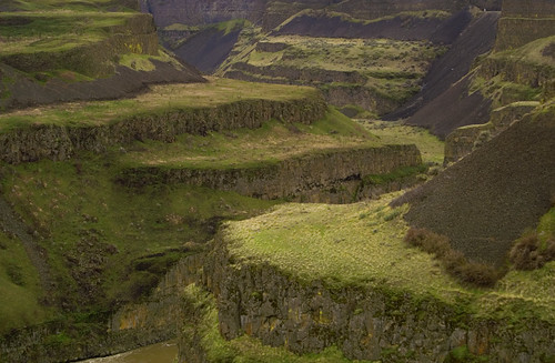
Ice Age Floods National Geologic Trail, an auto tour route that also continues into Oregon, is hoped to bring tourism to communities in the southern parts of those states, through the sagebrush-scattered steppes and channelled scablands scoured deeply the last time the ice melted. (picture is of channeled scablands in Washington, near Grand Coulee.)
Speaking of Oregon....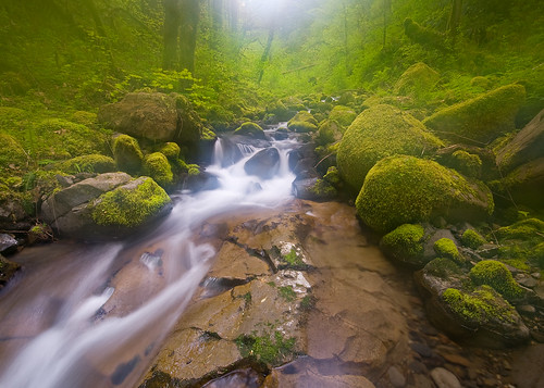
The Friends of Mount Hood have been working for 20+ years to protect the lands on Portland's favorite mountain. They scored a major victory with the inclusion of the Lewis and Clark Mount Hood Wilderness Act (included in the Omnibus), that protected 127,000 acres of the lush forests and wild rivers (picture of newly protected Eagle Creek). The protection of these areas has a practical side; the waters of Mount Hood affect the entire watershed, including Portland's municipal water system. The Oregon Badlands Wilderness, out in the desert, was fought for by the Oregon Natural Desert Association, who also fought for some 20 years to protect this area, arguing for the wilderness as an economic stimulant. Senator Wyden was an ally for these recreationists and conservationists who have succeeded in protecting these areas.
Oregon sites include:
WILDERNESS AREAS
Badger Creek Wilderness
Bull of the Woods Wilderness
Mount Hood Wilderness
Mark O. Hatfield Wilderness
Salmon-Huckleberry Wilderness
Clackamas Wilderness
Roaring River Wilderness
Lower White River Wilderness
Copper Salmon Wilderness
Oregon Badlands Wilderness
Soda Mountain Wilderness
WILD AND SCENIC RIVERS
South Fork Clackamas River
South Fork Roaring River
Elk River
Eagle Creek
Upper Zig Zag River
Middle Fork Hood River
East Fork Hood River
Fifteenmile Creek
Collawash River
Fish Creek
OTHER AREAS
Mount Hood National Recreation Area
Eagle Creek- Columbia River Gorge National Scenic Area
Sheep Creek Wild and Scenic River
Moving east, we get to Idaho
Large sections of the Owyhee uplands in southwestern Idaho got protected under the Public Lands Omnibus of 2009. The Owyhee features sage-covered rolling mesas cut deeply by the Bruneau, Jarbidge, and Owyhee Rivers, and their many tributaries (kayaker on the Bruneau in the picture). The diverse terrain supports many forms of wildlife, notably a large raptor population. Wilderness areas have been designated around the rivers, and the watersheds have also been protected for their wild and recreational value.
This almost-forgotten corner of Idaho has been growing in visibility thanks to a growing population of techno-jocks in Boise, who make spring pilgrimages to shoot rapids through the steep canyons, and have grown to appreciate the stark wildness of these lands. These granola-crunchers from the city forged a partnership with area ranchers, and the two groups persuaded conservative senator Mike Crapo to sponsor a comprehensive wilderness and wild river bill. Environmental groups, including the Sierra Club, have pledged to raise millions to buy private lands in the area, improving access and expanding habitat for the many wild creatures of the region, including the endangered sage grouse.
WILDERNESS AREAS
Little Jacks Creek Wilderness
Big Jacks Creek Wilderness
Bruneau-Jarbidge Rivers Wilderness
North Fork Owyhee River Wilderness
Pole Creek Wilderness
Owyhee River Wilderness
WILD AND SCENIC RIVERS
Battle Creek
Big Jacks Creek + Wickahoney Creek + Cottonwood Creek + Duncan Creek
Bruneau River
Jarbidge River
Deep Creek, including Dickshooter Creek
Little Jacks Creek
North Fork of the Owyhee River
Owyhee River
Red Canyon
Sheep Creek
South Fork of the Owyhee River
And on to Wyoming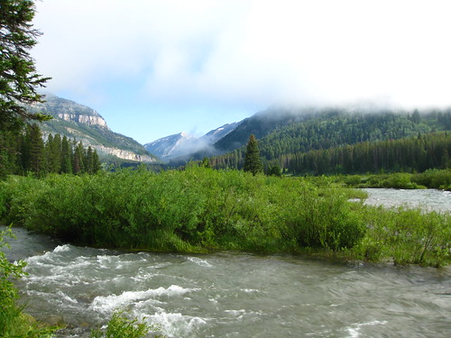
The grassroots environmentalists of the northwest have had a lot of successes to celebrate over the years, thanks in part to the deep pockets found in liberal Jackson Hole. I would certainly argue that the deep pockets of Teton County, where people have among the highest average per-capita incomes in the nation, is thanks to early and aggressive preservation of wild lands. Yellowstone was the first of our lands to be "set aside for the enjoyment of the people, and preserved for future generations" and local ranchers persuaded John D. Rockefeller to sponsor the establishment of Grand Teton National Park. Lyndon Johnson designated the numerous wilderness areas around the valley. These protections made Jackson Hole a rare place to live, which has drawn so many billionaires (so the joke goes) that all the millionaires had to pack their bags and move to Cody. This bill protects the waters of Jackson Hole, the headwaters for the entire Snake River system, which ultimately joins the Columbia. The Headwaters of the Snake River have their origin in Yellowstone National Park, Grand Teton National Park, the Teton Wilderness, the Gros Ventre Wilderness, and the Bridger Teton National Forest.
South into Colorado 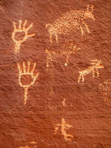
In Colorado, the backcountry of Rocky Mountain National Park has been designated a wilderness. As visitation to the parks increases, I think it's fine to set aside the backcountry as wilderness to ensure that no one gets funny ideas about helipads and backcountry luxury hotels.
The Public Lands Omnibus also designated the Dominguez-Escalante National Conservation Area, including Dominguez Canyon Wilderness Area, just south of Grand Junction. We can thank the Colorado Environmental Coalition in part for this addition, which not only protects diverse wildlife habitats, and paleontological, archeological and historical sites (rock art panel pictured), but also includes the system in the National Landscape Conservation System. Meaning, recreational development-- in the form of a multi-use trail system-- will be funded (we hope).
New Mexico, Land of Enchantment 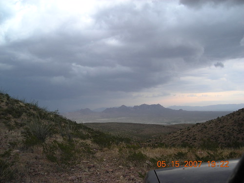
New Mexico Wilderness Alliance, and the many other groups who work to protect our fragile deserts and mountains, can celebrate three newly-protected areas on BLM lands around the state. Did I also mention we have an AWESOME congressional delegation?
The Prehistoric Trackways National Monument in the Robledo Mountains near Doña Ana (pictured), is one of the finest Paleozoic paleontological sites in the country. Most of the specimens have been removed to the New Mexico Museum of Natural History in Albuquerque, but the mountains are a challenging and fascinating place to explore.
Fort Stanton-Snowy River Cave National Conservation Area above ground, is a historic fort, dating from the late 19th century, nestled in the foothills of the Sacramento Mountains. Underground is a wonderland formed over eons. Permit required for caving.
Sabinoso Wilderness The Sabinoso wilderness does not currently have public access, but protects over 16,000 acres of mesas and canyons.
On to Arizona!
When the Public Lands Omnibus of 2009 was signed into law, some favorite places in Arizona got new protections. Fossil Creek (in the picture) was designated a Wild and Scenic River-- Arizona's second, and part of the system that feeds the wild and scenic Verde River.
The Mazatzal Wilderness got some additional land.
The Arizona National Scenic Trail, long a dream of dedicated volunteers, has received national status. This trail passes through some of the wildest and most beautiful public lands of the state, from the Grand Canyon to the saguaro forests. Like the Pacific Northwest National Scenic Trail, this is the product of dozens of heroic individuals who have been literally laboring for years, in the hot sun and the cold chill of courtrooms, to get all the pieces built and connected.
Across the border, in Utah...
We meet the wildly active folks of the Southern Utah Wilderness Alliance and the Citizens for Dixie's Future, who crafted a plan for protecting lands in Washington County, the far southwestern corner of Utah, where the Colorado Plateau merges with the Great Basin and Mojave deserts.
180,000 acres of this unique landscape-- including Canaan Mountain, Black Ridge, Beaver Dam Wash, and Doc's Pass-- were protected under this law, including Utah's first wild river, the system of tributaries to the Virgin River, flowing through Zion National Park. The backcountry of Zion has mostly been designated as wilderness. Tiny little wilderness areas on the BLM lands around Zion protect the sources of the wild waters. It's worth noting that Zion has been succesfully pioneering methods for fulfilling Edwards Abbey's dream of making parks for people, not cars. They have low carbon buses that shuttle visitors from point to point. I do believe their food concession is also serving local agricultural products. At any rate, the newly-protected Utah sites include:
WILDERNESS
Beartrap Canyon Wilderness
Blackridge Wilderness
Canaan Mountain Wilderness
Cottonwood Forest Wilderness
Cougar Canyon Wilderness
Deep Creek Wilderness
Doc's Pass Wilderness
Goose Creek Wilderness
LaVerkin Creek Wilderness
Red Butte Wilderness
Red Mountain Wilderness
Slaughter Creek Wilderness
Taylor Creek Wilderness
Zion Wilderness
OTHER AREAS
The Red Cliffs and the Beaver Dam Wash National Conservation Areas are more pieces for the BLM's National Landscape Conservation System. For those not familiar with this rather obscure division, it was created under Clinton by my hero, Bruce Babbitt, who rightly argued that the BLM should shift its focus from mineral and grazing management to managing for recreation and preservation. At his urging, Clinton used the nuclear weapon of public lands, the Antiquities Act, to shove through protections on the first "landscape protection," of Grand Staircase-Escalante National Monument, which turned out to be such a great success for locals and recreationists, that when he went to put through a bunch more (twice) he met much less resistance. Under Bush, the BLM was directed to process gas and mineral leases at high speed and radically underfunded the NCLS. I am hoping that this law is an indication that under Salazar, the BLM will try to shift away from the extractive, consumptive, land-destroying activities of the last 8 years, and look to taking care of its treasures.
Red Cliffs National Conservation Area, including Cottonwood Canyon Wilderness
Beaver Dam Wash National Conservation Area
Tributaries to the Virgin Wild and Scenic River
And the promised land of.... California!
I get so sad when I think about California. Population pressures have fragmented or destroyed so much of what must have been an amazing paradise, particularly along the coast. But California is big! Senator Barbara Boxer sponsored legislation to protect areas around Palm Desert/ Twentynine Palms and in the eastern Sierras, around King's Canyon/ Sequoia/ Yosemite/ Mono Lake.  The California Wilderness Coalition and the Friends of the Inyo National Forest are two of the volunteer organizations that recognized the importance of protecting these remaining "untrammeled lands" and wild waters, and persuaded locals, federal managers, and Congress to preserve them in perpetuity. The picture is of the ancient bristlecone pine forest, where some of the oldest trees in the world are growing, now protected to awe future generations. The total acreage of new wilderness in California is over 700,000 acres, many designated to protect important watersheds. A nod to motorized users includes two winter recreation areas in the White Mountains.
WILDERNESS
Hoover Wilderness addition
John Muir Wilderness addition
Ansel Adams wilderness addition
Agua Tibia Wilderness addition
Santa Rosa Wilderness addition
Joshua Tree Wilderness addition
Orocopia Mountains Wilderness addition
Palen/McCoy Wilderness addition
Chuckwalla Mountains Wilderness addition
Sequoia-Kings Canyon Wilderness
Owens River Headwaters Wilderness
White Mountains Wilderness
Granite Mountain Wilderness
Magic Mountain Wilderness
Pleasant View Ridge Wilderness
Cahuilla Mountain Wilderness
South Fork San Jacinto Wilderness
Beauty Mountain Wilderness
Pinto Mountains Wilderness
John Krebs Wilderness
OTHER NEW AREAS
Bridgeport Winter Recreation Area
Pickel Hill Management Area
Ancient Bristlecone Pine Forest
WILD AND SCENIC RIVERS
Amargosa River
Owens River Headwaters
Cottonwood Creek
North Fork San Jacinto River & Fuller Mill Creek
Palm Canyon Creek
Bautista Creek
Many thanks Senator Bingaman (D! From NM!) for putting all the varied grassroots proposals proposals together & shepherding it through, also all the other senators who listened to the local groups in their area and protected important lands and waters. And thank you, Jorge Silva-Bañuelos in Bingaman's DC office for sending me all those lovely maps. There's lots of other stuff in the bill too! Water conservation! Eastern things! Great fun for everyone!
Disclaimer: many links go the Public Lands Information Center, a service of the Public Lands Interpretive Association. I am the webmaster for this site & wrote the rec info, but this post is my own opinion, and does not in any way represent the views of the PLIA. The pictures are not mine, but I was knocked out when looking through the flickr files by how many people love love love these places!.
